
Oxford Archaeological Plan
Oxford City Council, 2013. https://doi.org/10.5284/1022572. How to cite using this DOI
Data copyright © Oxford City Council unless otherwise stated
This work is licensed under the ADS Terms of Use and Access.

Primary contact
David
Radford
Archaeologist
Heritage and Specialist Services
Oxford City Council
St Aldate's Chambers
109-113 St Aldate's
Oxford
OX1 1DS
Tel: 01865 252605
Resource identifiers
- ADS Collection: 1626
- DOI:https://doi.org/10.5284/1022572
- How to cite using this DOI

Downloads
Archaeological Resource Assessment | Historic Landscape and Urban Characterisation | Statements of Archaeological Interest | Oxford Archaeological Action Plan |
Historic Landscape and Urban Characterisation
Methodology
|
Urban Characterisation Methodology | 2 Mb |
Documentation
| Oxford Archaeological Plan ads gis file metadata | 156 Kb | |
| Oxford Archaeological Plan ads gis project metadata | 192 Kb |
Zipped Shapefiles files
| Central Oxford Tenement survival assessment based on research of Rev HE Salter | ZIP | 892 Kb |
| Historic Landscape and Urban Characterisation for Oxford 1876 | ZIP | 891 Kb |
| Historic Landscape and Urban Characterisation for Oxford 2010 | ZIP | 891 Kb |
Urban Character Reports
|
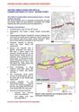
Historic Urban Characterisation-Introduction and overview map | 5 Mb | |
|
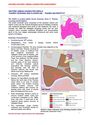
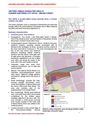
HUCA 01-Osney Island-Mill Street and Botley Road | 1 Mb | |
|
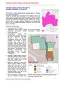
HUCA 02-Osney Island-Osney Abbey | 1 Mb | |

|
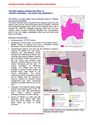
HUCA 03-Osney Island-Transport and Business | 1 Mb | |
|
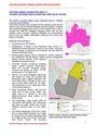
HUCA 04-Osney Island-Open Recreation | 1 Mb | |
|
HUCA 05-The Western Suburb-Rersidential | 1 Mb | |
|
HUCA 06-The Western Suburb-Factories and Offices | 1 Mb | |
|
HUCA 07-The Western Suburb-Castle Mill Stream and Fisher Row | 1 Mb | |
|
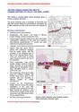
HUCA 08-Thames Crossing and Floodplain-Thames Waterfront | 1 Mb | |
|
HUCA 09-Thames Crossing-St Aldates | 1 Mb | |
|
HUCA 10-Thames Crossing-Colleges and University | 1 Mb | |
|
HUCA 11-Thames Crossing and Floodplain-Westgate Centre | 1 Mb | |
|
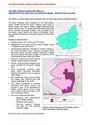
HUCA 12-Castle and Periphery-Oxford Castle | 1 Mb | |
|
HUCA 13-Castle and Periphery-Nuffield Colledge | 1 Mb | |
|
HUCA 14-Castle and Periphery-Former Canal Basin | 901 Kb | |
|
HUCA 15-City Centre and Commercial Core-Pembroke Street and St Aldates | 1 Mb | |
|
HUCA 16-City Centre Commercial-Queen Street and Bonn Square | 1 Mb | |
|
HUCA 17-City Centre Commercial Core-New Inn Hall Street | 1 Mb | |
|
HUCA 18-City Centre Commercial Core-Cornmarket | 1 Mb | |
|
HUCA 19-City Centre Commercial-The High Street-Town Houses and Market | 1 Mb | |
|
HUCA 20-Former Northern City Ditch-George Street | 1 Mb | |
|
HUCA 21-Former Northern City Ditch-Broad Street | 1 Mb | |
|
HUCA 22-Former Northern City Ditch-Holywell Street | 1 Mb | |
|
HUCA 23-Worcester College and Gloucester Green-Worcester College | 1 Mb | |
|
HUCA 24-Worcester College and Gloucester Green-Gloucester Green | 1 Mb | |
|
HUCA 25-Worcester College and Gloucester Green-Beaumont Street and St John Street | 1 Mb | |
|
HUCA 26-St Giles-The Street and Islands | 1 Mb | |
|
HUCA 27-St Giles-Western Frontage Commercial | 1 Mb | |
|
HUCA 28-St Giles-Ashmolean Museum and Colleges | 1 Mb | |
|
HUCA 29-St Giles-Townhouses | 1 Mb | |
|
HUCA 30-St Giles-St Johns College Expansion | 1 Mb | |

|
HUCA 31-St Giles-Medieval Colleges | 1 Mb | |
|
HUCA 32-The Eastern Colleges-Turl Street Colleges | 1 Mb | |
|
HUCA 33-The Eastern Colleges-University Buildings | 1 Mb | |
|
HUCA 34-The Eastern Colleges-South of the High Street | 1 Mb | |
|
HUCA 35-The Eastern Colleges-Broad Walk | 1 Mb | |
|
HUCA 36-The Eastern Colleges-Former Eastgate | 1 Mb | |
|
HUCA 37-The Eastern Colleges-North of the High Street | 1 Mb | |
|
HUCA 38-Holywell and Northeast Expansion-Mansfield Road | 1 Mb | |
|
HUCA 39-Holywell and Northeast Expansion-Modern Colleges | 1 Mb | |
|
HUCA 40-Holywell Historic Core | 1 Mb | |
|
HUCA 41-The Eastern Suburb-Magdalen College | 1 Mb | |
|
HUCA 42-The Eastern Suburb-Botanic Garden | 1 Mb | |
|
HUCA 43-St Clements-Commercial and Residential | 1 Mb | |
|
HUCA 44-St Clements-St Hildas College and Magdalen School | 1 Mb |
