
The Archaeological Landscape of Frampton on Severn, Gloucestershire
Gloucestershire County Council, 2014. https://doi.org/10.5284/1025046. How to cite using this DOI
Data copyright © Gloucestershire County Council unless otherwise stated
This work is licensed under the ADS Terms of Use and Access.


Primary contact
Toby
Catchpole
Archaeology Service
Gloucestershire County Council
Shire Hall
Westgate Street
Gloucester
GL1 2TH
England
Tel: 01452 425681
Fax: 01452 425356
Resource identifiers
- ADS Collection: 1619
- ALSF Project Number: 4625
- ALSF Project Number: 5171
- DOI:https://doi.org/10.5284/1025046
- How to cite using this DOI

Downloads
Reports
- ALSF 4625 and 5171 Final report, Mullin 2011
- ALSF 5171 Post-excavation assessment and updated project design, Mullin 2007
- ALSF 5171 Project design for post-excavation assessment, Mullin 2007
- ALSF 5171 Evaluation report and updated project design, Catchpole 2006
- ALSF 4625 Updated project design, Mullin 2006
- ALSF 4625 NMP report, Dickson 2007
ALSF 4625 Updated project design
Mullin, D., 2006, The Archaeological Landscape of Frampton on Severn, Gloucestershire. Updated Project Design
|
Report text | 1 Mb | |
|
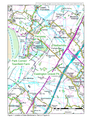
Figure 1: Location of sites mentioned in text | 723 Kb | |
|
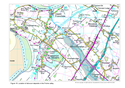
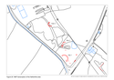
Figure 2: Detailed location of sites mentioned in text | 249 Kb | |
|
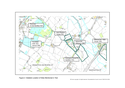
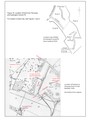
Figure 3: Location of Netherhills Sites 1, 2 and 3 | 728 Kb | |
|
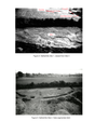
Figure 4: Netherhills Site 1; Figure 5: Netherhills Site 2 | 4 Mb | |
|
Figure 6: Netherhills Site 3; Figure 7: Netherhills Site 3 internal pit | 1 Mb | |
|
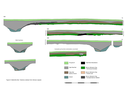
Figure 8: Netherhills Site 1 Sections | 78 Kb | |
|
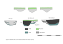
Figure 9: Netherhills Sites 2 and 3 Sections | 55 Kb | |
|
Figure 10: Netherhills Sites 4 and 5 Sections | 805 Kb | |
|
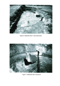
Figure 11: Netherhills Site 1 cremation pit; Figure 12: Secondary skeleton from ditch of Netherhills Site 1 | 7 Mb | |
|
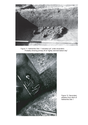
Figure 13: The cremation pit at Netherhills Site 1 | 1 Mb | |
|
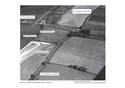
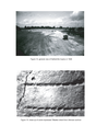
Figure 14: General view of Netherhills Quarry in 1948; Figure 15: Comb-impressed ?Beaker sherd | 5 Mb | |
|
Figure 16: Location of finds from Perryway and Eastington Gravel Pit | 1 Mb | |
|
Figure 17: Round barrows and ring ditches in Gloucestershire | 2 Mb | |
|
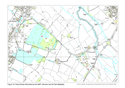
Figure 18: Location of alluvium deposits in the Frome valley | 806 Kb | |
|
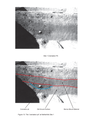
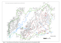
Figure 19: Ring ditches recorded by the NMP | 2 Mb | |
|
Figure 20: NMP transcription of the Netherhills area | 77 Kb |
