England's Historic Seascapes: Withernsea to Skegness

Museum of London Archaeology, 2010. https://doi.org/10.5284/1000104. How to cite using this DOI

Digital Object Identifiers

Digital Object Identifiers (DOIs) are persistent identifiers which can be used to consistently and accurately reference digital objects and/or content. The DOIs provide a way for the ADS resources to be cited in a similar fashion to traditional scholarly materials. More information on DOIs at the ADS can be found on our help page.

Citing this DOI

The updated Crossref DOI Display guidelines recommend that DOIs should be displayed in the following format:

https://doi.org/10.5284/1000104
Sample Citation for this DOI

Museum of London Archaeology (2010) England's Historic Seascapes: Withernsea to Skegness [data-set]. York: Archaeology Data Service [distributor] https://doi.org/10.5284/1000104

Data copyright © Historic England unless otherwise stated

This work is licensed under the ADS Terms of Use and Access.
Creative Commons License


Aggregates Levy Sustainability Fund logo
Historic England logo

Primary contact

David Bowsher
Director of Research
Museum of London Archaeology
Mortimer Wheeler House
46 Eagle Wharf Road
London
N1 7ED
UK
Tel: 020 7410 2285

Send e-mail enquiry

Resource identifiers

Digital Object Identifiers

Digital Object Identifiers (DOIs) are persistent identifiers which can be used to consistently and accurately reference digital objects and/or content. The DOIs provide a way for the ADS resources to be cited in a similar fashion to traditional scholarly materials. More information on DOIs at the ADS can be found on our help page.

Citing this DOI

The updated Crossref DOI Display guidelines recommend that DOIs should be displayed in the following format:

https://doi.org/10.5284/1000104
Sample Citation for this DOI

Museum of London Archaeology (2010) England's Historic Seascapes: Withernsea to Skegness [data-set]. York: Archaeology Data Service [distributor] https://doi.org/10.5284/1000104

Map Viewer

The map below shows the study area divided into Character Areas. Click on an area of the map to view the full Character Area description.
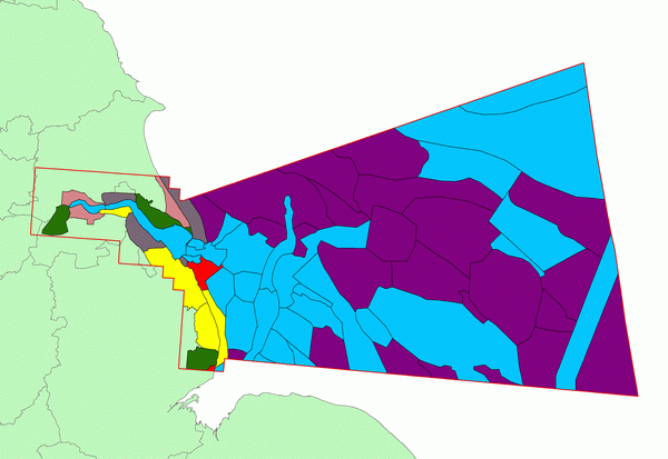
character map
 

Key:

legendOffshore Industry
legendRecreation
legendSettlement
legendCoastal Industry
legendFlood defence and reclamation
legendMilitary
legendNavigation

Character Areas

Hover your mouse icon over a zone to view its name; left click to view the full Character Area description.
 
Amethyst West Amethyst East Rough Galleon Saturn Sole Pit Well Hole Off Ground Well Bank Flats Outer Silver Pit Dogger Bank Well Bank Markham's Hole North Sea Traffic Route Indefatigable Banks Valiant Leman Ground Brigantine Gas Field North Sea transport route Indefatigable West Hole Leman Bessemer Gas Field Ower Bank North Hewett Hewett Cromer Knoll Outer Dowsing Shoals Outer Dowsing Outer Dowsing Navigation Channel Triton Knoll Dudgeon Shoals Sheringham Shoal Race Bank and North Ridge Race Bank Channel Docking Shoal Burnham Flats Ouse Nene Silver Pit Humber Mouth Protector Overfalls Inner Dowsing Lynn Wainfleet Sand Skegness to Wainfleet coast Outer Dogs Head Skegness and Mablethorpe coastal waters Mablethorpe to Skegness coast Theddlethorpe Overfalls Humber Gateway New Sand Hole Off Easington Withernsea to Spurn Point coast Spurn Point Sunk Island Coast Outer Humber Estuary Inner Humber Estuary The Binks Humber Estuary Mouth Haile Sand Flat Donna Nook Haile Sand Cleethorpes to Mablethorpe coast East Halton to Immingham Coast Barton to East Halton Coast Hull Coast Alkborough to Barton upon Humber Coast Blacktoft to Hessle coast Isle of Axeholme

ADS logo
Data Org logo
University of York logo