
England's Historic Seascapes: Withernsea to Skegness
Museum of London Archaeology, 2010. https://doi.org/10.5284/1000104. How to cite using this DOI
Data copyright © Historic England unless otherwise stated
This work is licensed under the ADS Terms of Use and Access.


Primary contact
David
Bowsher
Director of Research
Museum of London Archaeology
Mortimer Wheeler House
46 Eagle Wharf Road
London
N1 7ED
UK
Tel: 020 7410 2285
Resource identifiers
- ADS Collection: 935
- ALSF Project Number: 4730
- DOI:https://doi.org/10.5284/1000104
- How to cite using this DOI
Inner Humber Character Area
Present Day Form
The character area is situated in the north-western extent of the study area and comprises the Inner Humber Estuary from the Isle of Axholme to the Humber Bridge. The area is entirely Riverine and includes the active Humber channel and its drying areas. This part of the Estuary passes through the parishes of North Lincolnshire and East Riding of Yorkshire. The Geology of the area is chalk and boulder clay overlain by deep deposits of alluvium.
The Humber Estuary is the second largest coastal plain estuary in the UK. It has a very large tidal range - the mean spring tidal range is 5.7m at Spurn, 7.4m at Saltend and 6.9m at Hessle (which is 45 miles inland).
The Inner part of the Estuary is currently experiencing accretion which is causing its many sandbanks and islands to move around and increase in size (Hull University 1994).
Sea Use: Present
The area is dominated by characteristics associated with navigation. The tidal river estuary is a highly dynamic environment with lots of different channels and drying areas that present a continual hazard to navigation. As a result of the changing environment one of the major activities that takes place in the channel is maintenance dredging.
There are many named historic drying areas that can be traced back at least to the 1600s on maps, including Whitton Sand, Pudding Pie Sands, Read's Island and Redcliff Middle Sand. Read's Island is the most substantial of the sandbanks and was even occupied at one point. Before it became an island, the sandback was locally known as Old Warp in the early 19th century (Winteringham.info.com). The island is so named because the Read brothers began using the island soon after it came into existence. They reclaimed further land and built a house (ibid). The sand bars are also an important habitat for wild birds (East Riding of Yorkshire 2008).
As well as being a transport route the River is also fished, in particular for eel, at certain times of the year.
Sea Use: Past
The Inner Humber Estuary is the most ancient part of the estuary. Prior to the formation of this part of the River a palaeolake existed in the area and the ancient coastline was situated much further to the west, where the Humber Bridge still stands. At the end of the last ice age the lake drained into the sea and the inner estuary was formed was formed (Hull University Press 1994).
The Estuary has been used as a transport route and fishing area since the prehistoric period, for example some of the earliest known wooden boats in Europe were discovered on the foreshore at North Ferriby (Van de Noort 2000, 167). Many of the surrounding ancient settlements on the Estuary banks accessed the Estuary and grew up because of the opportunities it offered for transport and fishing.
The estuary was largely unconfined until the 12th century, after which it became increasingly embanked. Land was reclaimed in the area and used for agricultural purposes (ibid).
Archaeological Potential
The highly dynamic and constantly changing coastline in this area means that archaeological deposits are constantly being discovered along the line of the Estuary (Van de Noort 2000, 167). The area has high potential for discovery of prehistoric deposits. The most famous prehistoric finds of recent years were the Bronze Age North Ferriby boats, which date to the early second Millenium BC (ibid). The character area has potential for archaeology from all periods and the waterlogged environment means preservation of artefacts is typically good.
Character Perceptions
The Inner Humber Estuary is perceived as being a historic navigation channel, fishing area historic area and recreation area. It is particularly important as a nature reserve and has, for example, the largest grey seal population in Europe, along with many rare wild birds, fish and invertebrates (humberems.co.uk).
References
http://www.humberems.co.uk/humber/Others
Van de Noort, R, 2000 Reconstructing past wetland landscapes - two case studies from the Humber Wetlands, in Archaeology in the Severn Estuary 11 (2000), 163-174,
East Riding of Yorkshire, 2008, Humber Estuary: Landscape Character Type 23
http://www.winteringham.info/Local_History/Read_s_Island/read_s_island.html
University of Hull, 1994, Humber Estuary and Coast, Institute of Estuarine and Coastal Studies, University of Hull, November 1994
Images
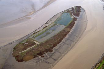
Read's Island, Humber Estuary
Web: http://www.wildlifeextra.com/images/reads-island.JPG
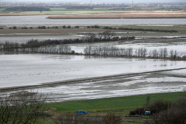
Whitton Sands, Humber Estuary
Web: http://www.geograph.org.uk/photos/34/99/349990_602eb31f.jpg
