
England's Historic Seascapes: Withernsea to Skegness
Museum of London Archaeology, 2010. https://doi.org/10.5284/1000104. How to cite using this DOI
Data copyright © Historic England unless otherwise stated
This work is licensed under the ADS Terms of Use and Access.


Primary contact
David
Bowsher
Director of Research
Museum of London Archaeology
Mortimer Wheeler House
46 Eagle Wharf Road
London
N1 7ED
UK
Tel: 020 7410 2285
Resource identifiers
- ADS Collection: 935
- ALSF Project Number: 4730
- DOI:https://doi.org/10.5284/1000104
- How to cite using this DOI
Barton to East Halton Coast Character Area
Present Day Form
This character area is located in the north-western extent of the study area in the parish of North Lincolnshire. The area is entirely land based but has historically influenced the local seascape to a significant degree. The area falls within the Humberhead Levels, a large area of very flat, low lying land lying towards the eastern end of the Humber estuary. It occupies the area of a former glacial palaeolake.
The character area is bounded to the east by the Yorkshire Wolds and the northern Lincolnshire Edge and to the west by the southern part of the Yorkshire magnesian limestone ridge. In the north it merges with the slightly more undulating Vale of York close to the Escrick moraine and to the south it merges into the Trent Vale. The underlying geology in the character area consists of the upper cretaceous chalks of the Lincolnshire Wolds.
Sea Use: Present
The Barton to East Halton Coast area is dominated by recreational maritime settlement activities. It contains a number of old clay and quarry pits, which have been flooded and are now used as nature reserves and water sports such as angling.
The area also contains historic maritime settlements and historic active docks and dock related activity. Barton on Humber is a historic maritime settlement that has a number of buildings related to its previous and ongoing uses as a port. Many of these features are preserved in conservation areas.
There is also an active port located at Barrow Haven and a modern cargo dock at New Holland Docks. The ports rely on forward transportation of goods via railways. Railway stations were established at the sites in the 19th century.
Goxhill village, also in the character area, is no longer connected to the coastline but originally grew up because of the once active channel at Goxhill haven. Goxhill has more recently been famed for its WWII airfield, now disused but still extant.
Sea Use: Past
The area lies in a flood defended area and there has been a continual interaction with the encroaching tide. It is documented that many of the houses in the villages regularly suffered from flooding. It is likely that some of the land in the area was reclaimed from the sea, but the date at which this occurred is not known.
There are a number of coastal settlements this character area which date back to at least the medieval period. Barton on Humber is recorded as dating from the 10th century. It has been the centre for many different types of industry over the centuries. A brickworks on the Humber foreshore used local clay to make bricks from 1703.
Barrow Haven originated as a small hamlet that grew up around a small ferry crossing to Hull. The ferry was eventually transferred across to New Holland docks (see below). Barrow Haven then became a cargo port and is still active, handling cargoes of timber from Scandinavia. It was also once renowned for its bricks and pantiles made from clay recovered from the edges of the Humber.
With the building of the railway line in 1848 the Barrow ferry service gradually disappeared as passengers preferred to embark from New Holland. Barrow Haven was also the site for an anti-aircraft battery, which provided protection for the city of Hull.
New Holland was formerly the embarkation point for the London & North Eastern Railway�s ferry service to Hull Victoria Pier. The ferry service was operational from 1820 to 1981, when the Humber Bridge opened.
Goxhill was also an important centre for clay pantile production since the 18th century. It is mostly famous for its wartime United States Army Air Forces (USAAF) base, where screen legend Clark Gable served for a short time.
Archaeological Potential
The Humberhead levels have been settled for several thousand years. The drier northern area was settled before the Roman era. The lighter soils there were easier to drain and it was extensively cleared for small scale pastoral farming. The system of easily navigable rivers was used by invading Angles and Danes to penetrate deep into the countryside.
The Barton on Humber area therefore has potential for prehistoric and later archaeology. The area has potential for Saxon archaeology and there is also the remains of a large motte and bailey castle. Extensive excavations were carried out in 1963 to determine the extent of the remains.
For centuries the thick layer of clay which borders the Humber estuary has been used to make tiles, bricks and cement. At the industry's height in the late 1800s, hundreds of men were employed to dig the clay by hand. The tile yards were abandoned in the 1950s, leaving the pits to fill naturally with water.
The area has also a potential for WWII archaeology. A WWII battery and disused WWII airfield were located in Barton on Humber.
Character Perceptions
It is perceived as being an important area for recreation (especially angling and nature reserves) and settlement. It is also an important area for industry, with imports of wood, etc, coming in from Scandinavia and elsewhere.
The Barton waterside area includes the Waters' Edge Country Park and the Far Ings National Nature Reserve. The North Lincolnshire and Humberside Sailing Club is at Barton Mere on the Humber to the east of Barton Waterside. It uses a former clay pit. Water's Edge Park is a home for wildfowl. Far Ings Nature Reserve is to the west of the Humber Bridge, and is run by the Lincolnshire Wildlife Trust.
References
Allan, 1833 The history of the county of Lincoln
"Humberhead Levels Character Area". English Nature.
http://www.naturalengland.org.uk/Images/jca39tcm2-21138_tcm6-4983.pdf
Kent, Sir Peter; Gaunt, G D (1980), Eastern England from the Tees to the Wash, British Regional Geology (Second ed.), London: HMSO. Natural Environment Research Council
Images
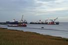
Humber sea terminal
Web: http://www.geograph.org.uk/photo/74796
