
Defence of Britain Archive
Council for British Archaeology, 2002. (updated 2006) https://doi.org/10.5284/1000327. How to cite using this DOI
Data copyright © Council for British Archaeology unless otherwise stated
This work is licensed under the ADS Terms of Use and Access.

Primary contact
Council for British Archaeology
92 Micklegate
York
YO1 6JX
England
Tel: +44 (0)1904
Fax: 671417
Resource identifiers
- ADS Collection: 324
- DOI:https://doi.org/10.5284/1000327
- How to cite using this DOI
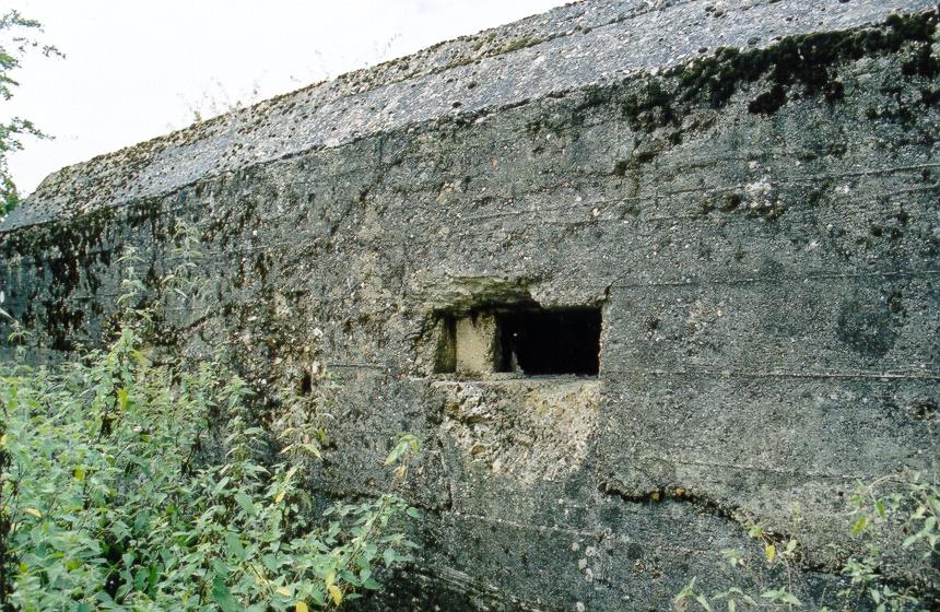
Rectangular anti-tank gun emplacement set back to back at a slight angle with another [see UORN 2682]. Shuttered with horizontal wooden planks, but vertical around the doorway (on N side). Corrugated iron-shuttered roof (internal). Cut-off corners and chamfered roof edge. One main embrasure, which has at some time been blocked but is now largely open. Internal LMG side chamber with two embrasures and further LMG embrasure in main body of emplacement. Possible shell-fire damage (target practice?) to the E and S faces, in particular around embrasures. Used as a cattle shelter. Faces S. Public access, including interior - close to footpath.
(Source: Field Visit 2003/09/03)
Type 28A 2pdr pillbox positioned back to back to fire with another [see UORN 2682].
(Source: Article 1994/12)
Rectangular structure plotted from OS 1:2500 sheet.
(Source: Map 1969)
Rectangular pillbox plotted from air photograph.
(Source: Air Photograph 1946/07/10)
| Type of site | PILLBOX (TYPE FW3/28A) |
|---|---|
| Location | E of the River Pang, on footpath running W-E from Sulham Hill to Sulham Lane, by the side of a small stream, N of Oaklands Farm. |
| Area |
Tidmarsh, Berkshire, England |
| Grid reference |
SU 63907 74755
|
| Period | WW2 |
| Condition | Good |
| Materials | Corrugated Iron, Reinforced Concrete, Wood |
| Recorder | Foot, William (English Heritage Defence Areas Project) |
| Defence grouping |
GHQ Line: Red (Sulham Valley sector) - Length of the GHQ Stop Line: Red running between the Rivers Thames and Kennet, along the line of the Sulham Valley west of Reading. |
| Photographs |
|
| DOB site reference: | S0016664 |
| Reference |
1946/07/10 106G/UK/1646 (fr.3290) |
| Event |
Construction, In the period 1940 1941 Field Visit, On 2003/09/03 |
